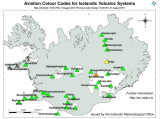
The Icelandic Met Office (IMO) has lowered the Aviation Colour Code for Bárðarbunga down to orange again, after raising the level to red this morning following the volcanic eruption in Holuhraun. The eruption is still ongoing but poses no threat to aviation. Further information on the Aviation Colour Code system can be found on the…
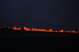
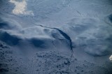
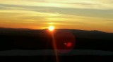
This morning around 5:15 o’clock a volcanic eruption started again in Holuhraun north of Dyngjujökull. The eruption is in the safe fissure that erupted on Friday. This eruption is bigger than the one on Friday but still considered a small eruption. The fissure is longer, both to the north and the south. The lava flows…
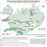
The Icelandic Met Office has decided to lower the aviation color code over Bardabunga from red to orange. The aviation restricted area declared by the Iceland Transport Authority has been lowered to a 3 nautical mile radius from the eruption site up to 5000 feet above ground. The area is closed off for all flights…
An eruption has started in Holuhraun north of Dyngjujökull at 00:02 this morning. An approximately 1 km long fissure (first estimate of scientists in the field) has opened, the eruption is purely effusive and no signs of explosive activity or ash emission has been detected so far. Based on volcanic tremor data, the eruption was…
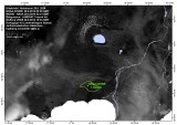
This picture shows the location of the volcanic eruption in Holuhraun north of Dyngjujökull. The picture is made by Institute of Earth Sciences at the University of Iceland. http://earthice.hi.is/
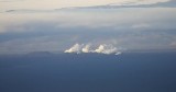
Volcanic eruption has started in Holuhraun, north of Dyngjujökull, which is located in northern Vatnajökull. The eruption is an lava eruption. At the moment the fissure is estimated to be around 100 meters long. ISAVIA the Icelandic Air Traffic and Control has closed the area above the eruption for all air traffic. The area can…
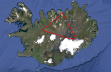
Scientists from the Icelandic Meteorological Office and the Institute of Earth Sciences, together with representatives of the Civil Protection in Iceland, met today to discuss the on-going unrest at the Bárðarbunga volcano. This morning, there was a flight over the Bárðarbunga area and the surface of the glacier was surveyed. No changes to the ice…
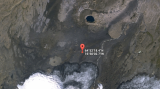
The Icelandic Coast Guard airplane TF-SIF is taking off from Reykjavík airport for Bárðarbunga. Yesterday the scientists onboard TF-SIF detected a 4-6 km long row of 10-15 m deep and 1 km wide cauldrons on the surface of Vatnajökull glacier. Conditions for surveillance from air were not good when the cauldrons were detected, making it…
27th August 2014 20:50 – info from a surveillance flight. Scientists from IES and IMO on a flight to Vatnajökull tonight discovered a row of 10-15 m deep cauldrons south of the Bárðarbunga caldera. They form a 6-4 km long line. The cauldrons have been formed as a result of melting, possibly a sub-glacial eruption,…