The access controlled area north of Vatnajökull glacier has been redefined
The National Commissioner of the Icelandic Police and Police Districts Commissioners in North East, East and Southern Iceland have decided (with reference to law on civil protection nr. 82/2008, article 23) to change the scope of the access controlled area north of Vatnajökull glacier. The decision is taken in close collaboration with the Icelandic Meteorological Office, Vatnajökull National Park, the Icelandic Environmental Agency and the Directorate of Health.
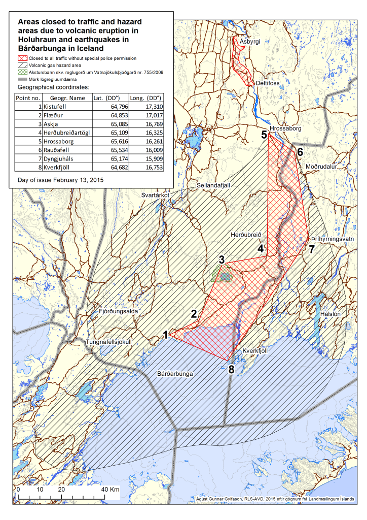
At the end of January The Icelandic Meteorological Office carried out a new hazard assessment for gas pollution from the volcanic eruption in Holuhraun. The new hazard assessment is based on the gradual decreased intensity of the volcanic eruption since October, seasonal weather conditions and regular monitoring of gas pollution at the eruption site. A model for weather conditions in the area over the last 10 years and given values of SO2 was also used in the hazard assessment. The risk map that now comes into effect is based on weather conditions in February until May and will be revised again before the summer.
Gas pollution from the volcanic eruption may even reach high levels outside the restricted area and for that reason the outer limits of the hazard area have not been changed. The hazard assessment for flood and volcanic ash are still valid. Those who travel inside the hazard area close to the restricted area are encouraged to be cautious and to take proper protective measurements and to be fully aware of the latest gas dispersion forecast published on the Icelandic Meteorological Office web site (http://en.vedur.is/)
Monitoring of gas pollution over the last few months shows that severe gas pollution can occur over Vatnajökull glacier from Flæður, over Kverkfjöll and to the south and east from those areas across the glacier.
A specific hazard assessment for glacial outburst flood, jökulhlaup, in Jökulsárgljúfur is being carried out. That area is still closed to all traffic. Hazard assessment for the eruption in Holuhraun and the unrest in Bárðarbunga is under constant revision and may be changed summarily.
Strict rules apply to the areas closed to traffic. The closed area around the eruption site is demarcated by lines drawn sequentially between the points listed in the table below:
|
Number |
Latitude |
Longitude |
|
1 |
64,796 |
17,310 |
|
2 |
64,853 |
17,017 |
|
3 |
65,085 |
16,769 |
|
4 |
65,109 |
16,325 |
|
5 |
65,616 |
16,261 |
|
6 |
65,534 |
16,009 |
|
7 |
65,174 |
15,909 |
|
8 |
64,682 |
16,753 |
For further information, see here.