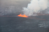
The volcanic eruption in Holuhraun continues into the new year, 2015, with similar intensity as it did in the last few weeks of the old year. Lava is still flowing in tens of qubic meters per second from the crader, building a constantly growing lava field in the sandy area north of Vatnajokull glacier. The…
The Scientific Advisory Board of the Icelandic Civil Protection met yesterday, 8. December, as it does regularly three days a week. The scenarios, for the most likely development of the volcanic eruption in Holuhraun and the subsidence of Bardarbunga caldera, were reviewed at the meeting. As all devoted readers of our notes (published here) know,…
Today, December 3rd 2014, the Scientific Advisory Board of the Icelandic Civil Protection reviewed data about the development of events in Bardarbunga and the volcanic eruption in Holuhraun, from the beginning of the unrest until the present day. Most of the data show a decline in the subsidence of the Bardarbunga caldera and the volcanic…
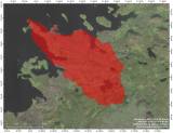
The eruption in Holuhraun has been active for 50 days, but it started on the 31 of August. The eruption continues at a similar intensity as before and lava production is steady. Now the size of the lavafield is around 60 km2 as shown on the map below.
This morning the gas pollution from Holuhraun has been mostly towards the northeast of the volcano. SMS warning messages were sent to all mobile phones in the area of Jökuldalur around noon, since the SO2 values were measured quite high. Handheld gas detectors that have been in use around Iceland, measured increased concentration of SO2 in the northeast and southeast of the country, especially in Borgarfjörður eystri and…
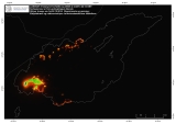
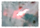
The picture below is taken by MODIS satellite at 03:46 tonight. The red colour shows a heat deviation and the white colour maximum heat radiation. According to scientists in the field the lava flow did cross the track into Holuhraun tonight. The lava field is growing to north east. The picture is compiled and published…
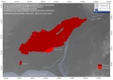
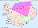
The Icelandic Met Office measures SO2 at the eruption site and issues daily forecast on SO2 concentration in the atmosphere based on SO2 measurements and weather conditions. This is a link for the spread forecast (in Icelandic language): 2 days spread forecast There are 2 maps that show forecast for current day (green spread area) and for the next day (pink…
We have added a new entry on the menu on the top right side of our web page. It is called The Civil Protection Advisory Board, and there we will store all reports coming from those meetings in the future. We will also collect old reports and file them on that page as well. These…
Today light southwesterly winds are expected at the eruption site in Holuhraun. Areas norheast of the eruption site can be affected by pollution. They are marked by Mt. Herðubreið in the north to Mt. Kárahnjúkar in the south. So Sulphur dioxide (SO2) concentration could become high in the eruption vicinity in Holuhraun and to the…
The concentration of SO2 (Sulphur Dioxide) is increasing in Kópasker and the surrounding area in northeastern Iceland. No gas monitoring is in the area but the inhabitants have felt the pollution and symptoms. Inhabitants are advised to close all windows and turn up the heat inside, while the concentration is high. Follow the Met Office…