An overview of the activity in Bardarbunga and the volcanic eruption in Holuhraun
- Today, December 3rd 2014, the Scientific Advisory Board of the Icelandic Civil Protection reviewed data about the development of events in Bardarbunga and the volcanic eruption in Holuhraun, from the beginning of the unrest until the present day. Most of the data show a decline in the subsidence of the Bardarbunga caldera and the volcanic eruption on Holuhraun. Earthquake activity is though still strong and the flow of lave great in comparison to volcanic eruptions in Iceland for over the last 100 years. The findings of the meetings are as follows:
- Earthquakes in Bardarbunga: Seismic activity has been very strong since mid-august. The activity peaked in first half of September, it has slowly decreased since then, but activity remains intense. The period of seismic unrest is one of the largest ever recorded in a volcano globally.
- Earthquakes in the dyke from Bardarbunga to Holuhraun: Strong seismic activity coincided with the progression of the dyke in the second half of August, but it decreased after the volcanic eruption began on Holuhraun. Earthquakes are still detected in the dyke but they are small and relatively few.
- Subsidence of the Bardarbunga caldera: In the days following the onset of the seismic unrest, the ice-covered base of the caldera began to subsidence up-to 80 cm a day, but the subsidence has since slowed and it is now around 25 cm per day. The subsidence is in the shape of a bowl and it is greatest in the centre of the caldera, about 50 m, but smaller to the edges.
- Crustal deformation: Extensive ground deformation Major was recorded while the dyke was forming, signalling the progression of the dyke and subsidence towards Bardarbunga. Interpretation of GPS data and analysis of satellite interferograms indicates that the volume of the magma in the dyke is about 0.5 cubic kilometres, and that it was fully formed by the beginning of the volcanic eruption. After the eruption started the subsidence has been steady, but slowly decreasing, towards Bardarbunga.
- The volcanic eruption in Holuhraun: The volcanic eruption that began on Holuhraun on 31 of August is characterised by a large and unusually steady flow of lava. The magma that comes up is a rather primitive basalt, with a chemical composition typical of the Bardarbunga volcanic system. The petrology analysis of the magma suggests that it stabilised at 9-20 km depth, meaning that it could not have resided at a shallower depth in the crust. The lava field is now 76 square kilometres in area. It is more difficult to measure the volume of the lava than the corresponding area. Measurements by air on 4th and 26th of November indicate that the volume of the lava is now about 1.0 cubic kilometre but the uncertainty is 0.3 cubic kilometres. The flow of lava was about 200 cubic meters per second in September but the average flow rate for November is estimated to have been under 100 cubic meters per second. The new lava field is the largest in Iceland since the Laki eruption (1783-1784) and it is probably the third largest lava field on the planet over that period.
- Gas: For the first time in 150 years, gas pollution from a volcanic eruption has had an impact in Iceland. The reason is the size and the long duration of the eruption. The flux of the sulphuric dioxide (SO2) in the gas cloud has been measured as high as 1300 kg per second, but the average flux in the first month of the eruption was estimated to have been 400 kg per second. Measurements of the total flux of gas at the eruption site are difficult and the uncertainty of these values are very high. It is probable that the flux of gas will decrease in line with decreasing flow of magma, but this has not been confirmed by measurements. A few cases of high SO2 concentration have been recorded in populated areas over the last few weeks compared to September and October, but in those cases weather conditions may have had an equally large effect as the flux of gas coming from the eruption site.
- If the unrest continues in a similar fashion, the subsidence of Bardarbunga and the volcanic eruption on Holuhraun will continue for at least some months. The situation could, of course, change so scenerios such a subglacial eruption remain a possibility.
- Two earthquakes stronger then M5,0 were detected in Bardarbunga from noon on Monday. The former was M5,2 on Monday, 1. December, at 12:52 on the south-eastern rim of the caldera and the second was M5,4 on Tuesday, 2. December, at 02:18 on the northern rim. Since noon on Monday 10 earthquakes between M4,0-5,0 were detected in Bardarbunga and 10 earthquakes between M3,0-4,0. In total about 120 earthquakes were detected in Bardarbunga during that time.
- Little seismic activity was detected in the dyke and around the eruption site in Holuhraun since Monday.
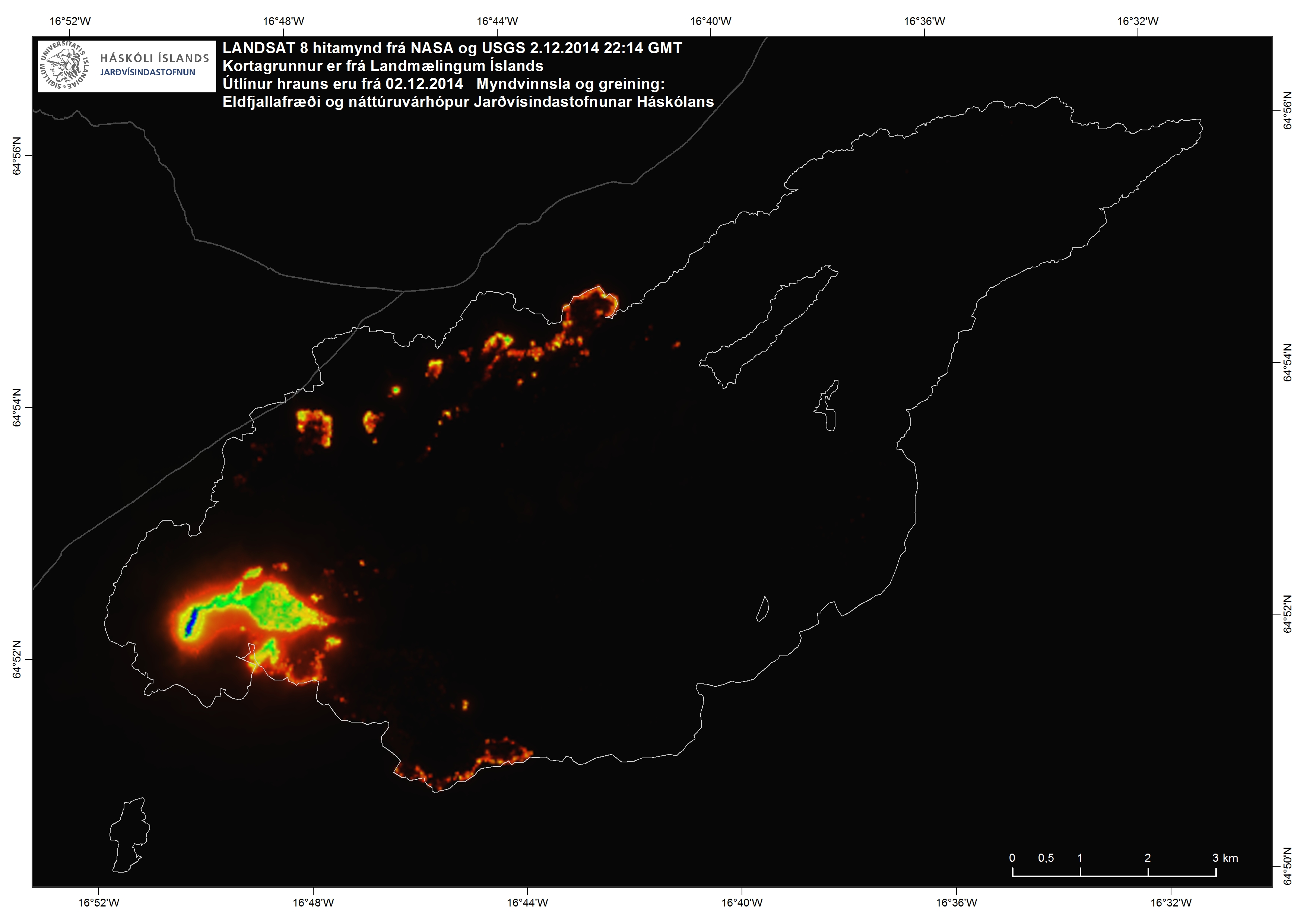
LANDSAT 8 image from NASA and USGS from 2.12.2014 at 22:14. Image by Institute of Earth Sciences University of Iceland.
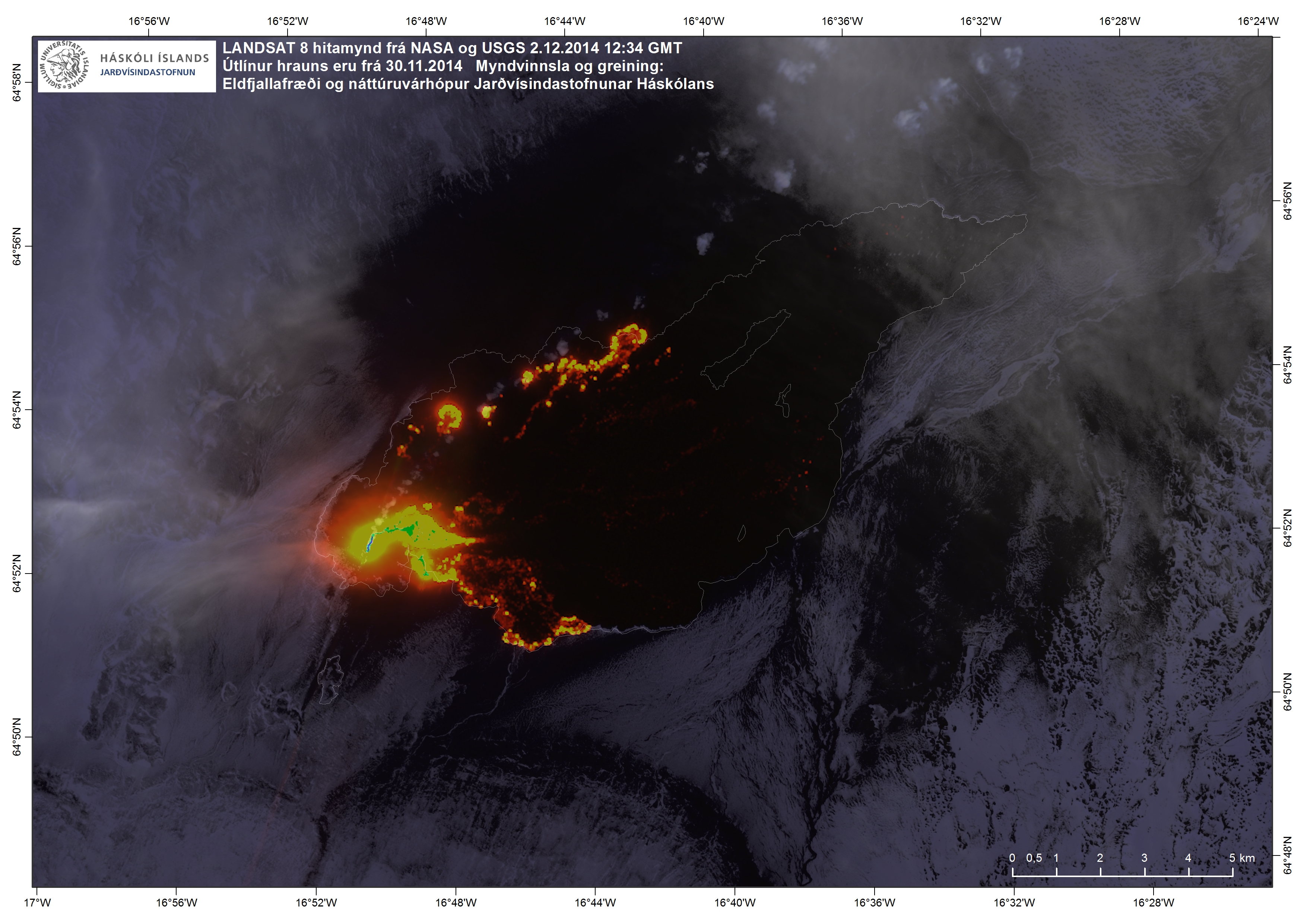
LANDSAT 8 image from NASA and USGS from 2.12.2014 at 12:34. Image by Institute of Earth Sciences University of Iceland.
