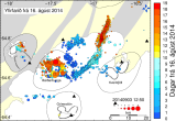
The map below shows all earthquakes that have been manually processed by the Icelandic Met Office (IMO) since 16 August 2014 when the wave of seismic activity started in Bardarbunga. Further information on the issue can be seen on the IMO web page.
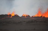
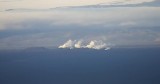
Einar Gudmann, an Icelandic photographer, has a web page with photos of the volcanic eruption in Holuhraun. This is a link to his page. The photo below is taken by Ármann Höskuldsson volcanologist who was one of the first to document the eruption.
The District Commissioner in Husavik has decided to lift the closure of road nr. 862, the section from the Ringroad to Dettifoss waterfall on the west side of Jökulsá á Fjöllum. The opening will take effect from 0800 on September 2nd. Other roads on the west side of Jökulsá are still closed including hiking trails.…
29.08.2014 13:17 The 3 nautical mile safety restricted flight area around the volcanic activity set by the Icelandic Transport Authority has been cancelled. No flight restrictions are in effect as a result of the volcanic eruption. http://www.isavia.is/
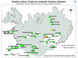
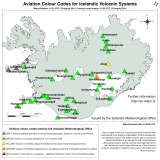
The Icelandic Met Office (IMO) has lowered the Aviation Colour Code for Bárðarbunga down to orange again, after raising the level to red this morning following the volcanic eruption in Holuhraun. The eruption is still ongoing but poses no threat to aviation. Further information on the Aviation Colour Code system can be found on the…
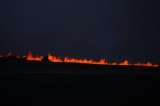
This morning around 5:15 o’clock a volcanic eruption started again in Holuhraun north of Dyngjujökull. The eruption is in the safe fissure that erupted on Friday. This eruption is bigger than the one on Friday but still considered a small eruption. The fissure is longer, both to the north and the south. The lava flows…
The Icelandic Met Office has decided to lower the aviation color code over Bardabunga from red to orange. The aviation restricted area declared by the Iceland Transport Authority has been lowered to a 3 nautical mile radius from the eruption site up to 5000 feet above ground. The area is closed off for all flights…
An eruption has started in Holuhraun north of Dyngjujökull at 00:02 this morning. An approximately 1 km long fissure (first estimate of scientists in the field) has opened, the eruption is purely effusive and no signs of explosive activity or ash emission has been detected so far. Based on volcanic tremor data, the eruption was…
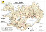
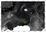
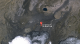
This picture shows the location of the volcanic eruption in Holuhraun north of Dyngjujökull. The picture is made by Institute of Earth Sciences at the University of Iceland. http://earthice.hi.is/