Scientific Advisory Board of the Icelandic Civil Protection 5. September
Bárðarbunga: 05.09.2014, 12:10 UTC
Scientists from the Icelandic Met Office and the Institute of Earth Sciences and representatives of the Civil Protection in Iceland attend the meetings of the Scientific Advisory Board of the Icelandic Civil Protection.
Conclusions of the Scientific Advisory Board of the Icelandic Civil Protection:
- At about 7:00 UTC this morning RÚV reported that new eruptive fissures had opened to the south of the on-going eruption.
- At 8:30, a surveillance flight with scientists from the IMO and University of Iceland observed the following
o Two new eruptive fissures formed south of the previous eruption site in Holuhraun, in a graben, that had formed above the intrusion, about 2km away from Dyngjujökull.
o The eruptive fire fountains from the new fissures are substantially smaller than in the older fissure. Steam and gas rises in a south eastern direction from the fissure.
o The cauldron in Dyngjujökull seems to have grown deeper since the last observation.
o No changes are visible in Bárðarbunga.
- Substantial amounts of SO2 are still being released to the atmosphere in association with the eruption.
- Conductivity measurements show a slight increase in conductivity in Jökulsá á Fjöllum.
- Some tremor was detected on seismometers shortly after 3:00 UTC last night. It decreased at about 6:00 UTC this morning.
- Considerable activity is in the northern fissure (fissure 1) and the height of the steam cloud is about 15,000 feet.
There are no indications of the eruption in Holuhraun being in decline. The lava from fissure 1 continues to flow to the east north east and has grown in area since yesterday.
- Seismicity in the area is similar to yesterday’s activity. About 170 earthquakes were detected since midnight. Two earthquakes of magnitudes 4,4 and 5,3 were detected in the Bárðarbunga caldera region at around midnight UTC.
- GPS displacements have continues to decrease and are now within uncertainty limits.
- Four scenarios are still likely:
o The migration of magma could stop, resulting in a gradual reduction in seismic activity and no further eruptions.
o The dike could reach the Earth’s surface at different locations outside the glacier. Lava flow and/or explosive activity cannot be excluded.
o The intrusion reaches the surface and another eruption occurs where either the fissure is partly or entirely beneath Dyngjujökull. This would most likely produce a flood in Jökulsá á Fjöllum and perhaps explosive, ash-producing activity.
o An eruption in Bárðarbunga. The eruption could cause an outburst flood and possibly an explosive, ash-producing activity. In the event of a subglacial eruption, it is most likely that flooding would affect Jökulsá á Fjöllum. However it is not possible to exclude the following flood paths: Skjálfandafljót, Kaldakvísl, Skaftá and Grímsvötn.
Other scenarios cannot be excluded.
From the Icelandic Met Office:
The Aviation Colour Code for Bárðarbunga remains at ‘orange’ and the code for Askja at ‘yellow’.
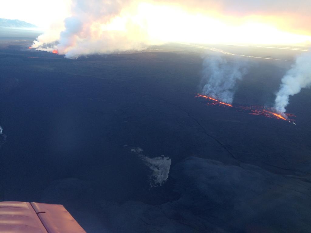
The new fissure that opened 5. September 2014. Photo by Lára Ómarsdóttir.
