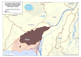
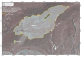
The Police District Commissioners in North Eastern, Eastern, Southern Iceland, and the National Commissioner of the Icelandic Police have decided to change the restricted area in Holuhraun with reference to the Civil Protection law no. 82/2008 article 23. The restricted area extends 20 m outside the edges of the new lava field, to the edge…
The Scientific Advisory Board of the Icelandic Civil Protection held a meeting this morning, Saturday 28th of February 2015, and sent out the following statement: The volcanic eruption in Holuhraun, which began on August 31st 2014, has come to an end. The area continues to be closely monitored. Gas contamination is still detected around the…
The National Commissioner of the Icelandic Police and Police Districts Commissioners in North East, East and Southern Iceland have decided (with reference to law on civil protection nr. 82/2008, article 23) to change the scope of the access controlled area north of Vatnajökull glacier. The decision is taken in close collaboration with the Icelandic Meteorological…
The Scientific Advisory Board met on Friday 30th of January 2015 and wrote this overview of the seismic activity in Bardarbunga and the volcanic eruption in Holuhraun. The document can be accessed here, with images and graphs, on pdf format. A powerful volcanic eruption is still on going in Holuhraun with a flow of lava…
The volcanic eruption in Holuhraun continues into the new year, 2015, with similar intensity as it did in the last few weeks of the old year. Lava is still flowing in tens of qubic meters per second from the crader, building a constantly growing lava field in the sandy area north of Vatnajokull glacier. The…
The Scientific Advisory Board of the Icelandic Civil Protection met yesterday, 8. December, as it does regularly three days a week. The scenarios, for the most likely development of the volcanic eruption in Holuhraun and the subsidence of Bardarbunga caldera, were reviewed at the meeting. As all devoted readers of our notes (published here) know,…
Today, December 3rd 2014, the Scientific Advisory Board of the Icelandic Civil Protection reviewed data about the development of events in Bardarbunga and the volcanic eruption in Holuhraun, from the beginning of the unrest until the present day. Most of the data show a decline in the subsidence of the Bardarbunga caldera and the volcanic…
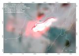
From the Icelandic Met Office: Today (Thursday) gas pollution from the eruption will affect areas in the northern part of Iceland. Tomorrow (Friday) pollution can be expected in the areas north and east of the eruption. The Gas Dispersion Forecast can be read on this web link. On the same site, here, you can find…
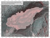
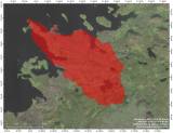
The picture below is taken by MODIS satellite at 03:46 tonight. The red colour shows a heat deviation and the white colour maximum heat radiation. According to scientists in the field the lava flow did cross the track into Holuhraun tonight. The lava field is growing to north east. The picture is compiled and published…
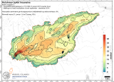
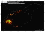
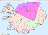
The Icelandic Met Office measures SO2 at the eruption site and issues daily forecast on SO2 concentration in the atmosphere based on SO2 measurements and weather conditions. This is a link for the spread forecast (in Icelandic language): 2 days spread forecast There are 2 maps that show forecast for current day (green spread area) and for the next day (pink…